ពួកនេះច្រើនប្រើឈ្មោះតែមួយ សំរាប់សំគាល់មនុស្សផងរាជធានីផងប្រទេសទាំងមូលផង រឺ ក៏ឈ្មោះឋានន្តរនាមរបស់អ្នកដឹកនាំផង។ ចំពោះទស្សនៈរបស់លោក សឺដេស នេះ គួរឲ្យកត់សំគាល់ថា ឯកសារចិនបាននិយាយច្បាស់ថាអធិរាជអាណាចក្រវ្នំមានឋានន្តរនាម គូឡុងគឺកុរុង ដែលសព្វថ្ងៃមានន័យថា ស្ដេចសោយរាជ្យ។ បើដូច្នេះ ពាក្យ ភ្វូណាន ចិនហៅតាមឋានន្តរនាមរបស់អធិរាជអាណាចក្រវ្នំ គឺ កុរុងវ្នំ នេះឯង។ ឯការដែលមានឋានន្តរនាមយ៉ាងនេះគឺប្រហែលមកពីភ្នំជាទីកន្លែងដែលអធិរាជឡើងទៅជួបនឹងព្រះឥសូរ ឯកសារចិនបាននិយាយថា ព្រះអាទិទេព យាងចុះលើភ្នំម៉ូតាន់ (Mo-tan) ជាញឹកញាប់ ព្រះអង្គបានមកទីនោះដើម្បីបញ្ចេញមហិទ្ធិរិទ្ធិរបស់ព្រះអង្គ ព្រះអធិរាជទាំងឡាយបានទទួលនូវពរជ័យពីព្រះអង្គ ហើយប្រជារាស្ត្រក៏បានសុខចំរើនដោយសារនោះផង។ ក៏ប៉ុន្តែ ណាន 南 ប្រហែលជាមានន័យសាមញ្ញថា ទិសខាងត្បូង ដែលគឺជាករណីយរដ្ឋដទៃទៀតមានឈ្មោះថា អណ្ណាម។ គេមានជំនឿថារដ្ឋនេះត្រូវបានបង្កើតឡើងនៅសតវត្សទី១នៃគ.ស នៅតំបន់ដីសណ្ដទន្លេមេគង្គ ដែលបច្ចុប្បន្នគឺជាទឹកដីវៀតណាម [៤] ក៏ប៉ុន្តែលំនៅដ្ឋានរបស់មនុស្សដ៏ច្រើនសន្ធឹកសន្ធាប់ នៅក្នុងតំបន់នោះប្រហែលជាត្រូវនឹងសតវត្សទី៤ម.គ ទៅវិញទេ។ ថ្វីបើត្រូវបានចាត់ទុកដោយពួកបេសកជនចិនថាជាអាណាចក្រឯកភាពមួយមែន វ្នំ ប្រហែលជាធ្លាប់ជាបណ្ដុំនៃរដ្ឋបុរីមួយចំនួនជួនកាលបានធ្វើសឹក នឹងរដ្ឋផ្សេងមួយទៀត និងនៅពេលមួយក៏បានបង្រួបបង្រួមនយោបាយគ្នាឡើងវិញ។

ផែនទីដែនដីនៃព្រះថោង នាងនាគ

ផែនទីដែនដីនៃព្រះថោង នាងនាគ
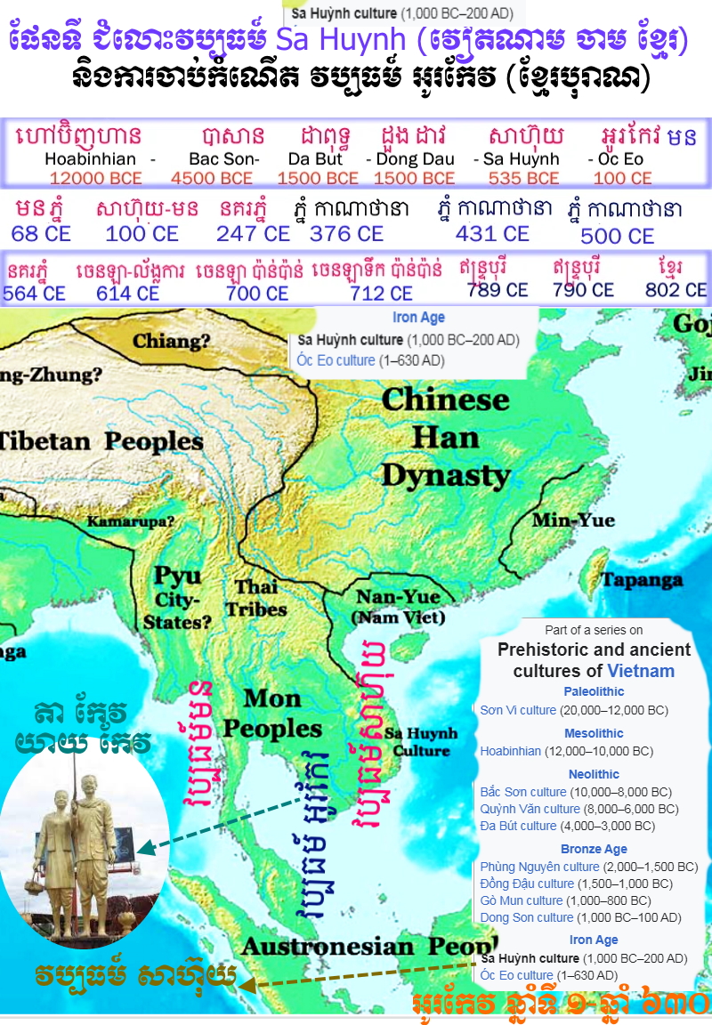
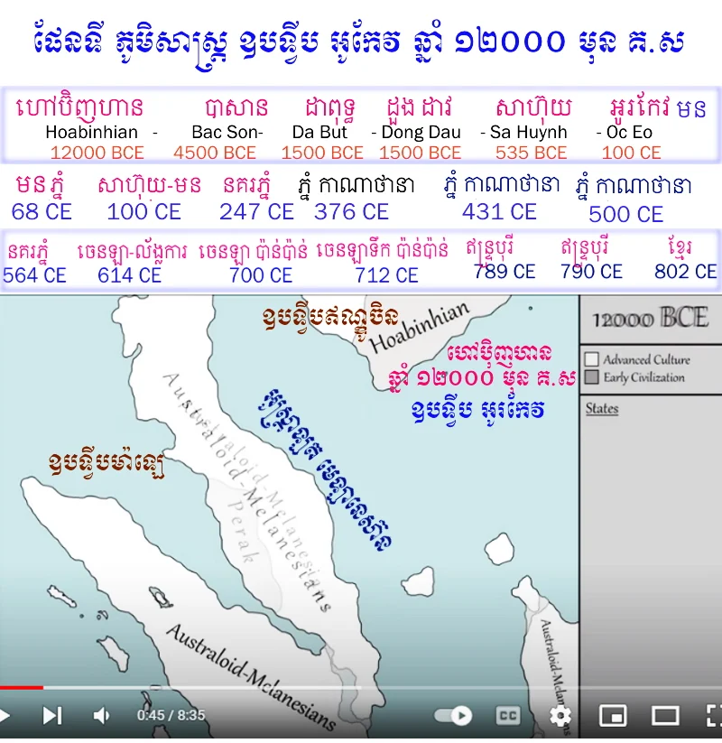
តិចណាស់ដែលគេដឹងអំពីវ្នំ វាលែងតែវាជារដ្ឋពាណិជ្ជកម្មដែលប្រកបដោយសក្ដានុពល បើតាមភស្តុតាងតាមរយៈការរកឃើញនៃទំនិញរបស់ពួករ៉ូម ចិន និងឥណ្ឌា កំឡុងពេលកំណាយបុរាណវត្ថុនៅកំពង់ផែបុរាណ អូរកែវ (O'Keo រឺ O'Ceo ) ដែលជាញឹកញយត្រូវបានសរសេរដោយភាន់ច្រឡំថាជា Oc Eo (អូរកែវ) នៅ
ប្រទេសវៀតណាមខាងត្បូង។ រាជធានីនៃនគរវ្នំប្រហែលជាដើមឡើយតាំង នៅបរិវេណបាភ្នំក្បែរទីប្រជុំជនបាណាមកម្ពុជាបច្ចុប្បន្ននៅក្នុង
ខេត្តព្រៃវែង ទំនងជាត្រូវបានគេផ្លាស់ទៅអូរកែវ នៅសម័យក្រោយមកទៀត។ វិខខឺរី (Vickery) បានច្រានចោលដោយកែតម្រូវលើការប្រកាសរកឃើញទីប្រជុំជនមួយដែលហៅថា វ្យាធបុរ (ទីក្រុងនៃអ្នកប្រមាញ់) ដោយលោកសឺដេស ពីព្រោះតែលោកបានទាញយកឈ្មោះពី ថឺមូ (Tèmù 特牧) ដែលគេលើកយកមកនិយាយជារាជធានីនៅក្នុងអត្ថបទប្រវត្តិសាស្ត្រចិន ដូច្នេះហើយវាត្រូវនឹងពាក្យខ្មែរថា ទ្មាក់ រឺ ទល្មាក់ ដែលមានន័យថា អ្នកទាក់ មិនមែន អ្នកប្រមាញ់ទេ។ ភាគច្រើនរឿងរ៉ាវដែលគេដឹងពីវ្នំ គឺបានមកពីកំណត់ត្រាពីប្រភពចិន និងចាម ដែលចុះកាលបរិច្ឆេទពីសតវត្សទី៣ដល់ទី៦ និងបានមកពីកំណាយបុរាណវត្ថុ។ គ្មានការស្រាវជ្រាវខាងបុរាណវត្ថុណាមួយត្រូវបានធ្វើឡើងនៅ ក្នុងរដ្ឋនេះក្នុងតំបន់ដីសណ្ដទន្លេមេគង្គ របស់កម្ពុជាជាច្រើនទសវត្សមកហើយ ហើយតំបន់នេះប្រាកដជា ជាទីតាំងដែលគេបានស្មានទុកថាជា ទីតាំងនៃរាជធានីជាច្រើននៃវ្នំ។ វ្នំត្រូវបានគេចាត់ទុកថាជានគរខ្មែរដំបូង (កាលនៅនគរវ្នំមិនដឹងថាអ្នកស្រុកហៅជាតិខ្លួនឯងថាម៉េចទេ វាលែងតែសម័យចេនឡាទើបយើងដឹងថាអ្នកស្រុកហៅខ្លួនឯងថាក្មេរ) និងជានគរមុន
កម្វុជទេឝ។
អ្នកប្រាជ្ញសម័យទំនើបទីមួយដែលកសាងប្រវត្តិសាស្ត្រនៃរដ្ឋបុរីវ្នំបុរាណឡើងវិញគឺលោក
ប៉ូល-ពេល្យោ ដែលក្នុងអត្ថបទប្លែកជាងគេ ឡឺភ្វូណន នៅឆ្នាំ ១៩០៣ បានទាញកំណត់ត្រាប្រវត្តិសាស្ត្រចិនដោយឡែកៗដើម្បីពិពណ៌នាពីលំដាប់ព្រឹត្តិការណ៍តាមឯកសារដែលភ្ជាប់ទៅនឹងការបង្កើតវ្នំនៅប្រហែលសតវត្សទី១នៃគ.ស ជាមួយការរលំរលាយទៅវិញដោយការសញ្ជ័យនៅសតវត្សទី៦ដល់ទី៧។ កត្តាសំខាន់នៃប្រភពចិនរបស់លោកពេល្យោបានបង្ហាញការសង្ស័យចំពោះការយល់ឃើញក្នុងសេចក្ដីសន្និដ្ឋានរបស់លោក។
[១០]កំណត់ត្រាចិនដែលចុះកាលបរិច្ឆេទចាប់ពីសតវត្សទី៣នៃគ.ស ដែលចាប់ផ្ដើមជាមួយសានគ័រជី (三國志) (
តំរានគរបី) បានបញ្ចប់នៅឆ្នាំ ២៨៩គ.ស ដោយលោក
ហ្ឆឹនឝូ (陳壽) (២៣៣-២៩៧) កត់ត្រាការមកដល់នៃគណៈទូតវ្នំពីរនៅឯសវនការនៃហ្លីតាយ (呂待) ចៅហ្វាយខេត្តនៅនគរអ៊ូ 吳 ចិនខាងត្បូង: គណៈទូតទីមួយបានមកដល់នៅរវាងឆ្នាំ ២២៥ និង ២៣០ គ.ស លើកទីពីរនៅឆ្នាំ ២៤៣។
[១១] ប្រភពក្រោយៗដូចជា លាំងឝ៊ូ (梁書) (
ក្រាំងលាំង) របស់
ហ្យ៉ោឆា 姚察 (៥៣៣-៦០៦) និង
ហ្យ៉ោហ្ស៊ឺហ្លៀន (姚思廉) (ស.៦៣៧) បានបញ្ចប់នៅឆ្នាំ ៦៣៦ ពិភាក្សាលើបេសកកម្មនៃបេសកជនចិនសតវត្សទី៣ខាងថាយ(康泰) និងជូយិង(朱應) ពីនគរអ៊ូទៅវ្នំ។ សំណេរនៃបេសកជនទាំងនេះ ទោះបីវាមិនស្ថិតនៅក្នុងស្ថានភាពដើមក៏ដោយ ក៏ត្រូវបានគេដកស្រង់និងវាគួរតែបានរក្សាទុកក្នុងប្រវត្តិសាស្ត្ររាជវង្សក្រោយៗមកទៀត ហើយនិងបង្កើតជាមូលដ្ឋានសំខាន់ដើម្បីឱ្យយើងយល់ដឹងច្រើនអំពីវ្នំ។ ចាប់តាំងពីការបោះពុម្ពផ្សាយអត្ថបទរបស់លោកពេល្យោ កំណាយបុរាណវត្ថុនៅ វៀតណាម និងកម្ពុជា ជាពិសេសកំណាយនៃស្ថានីយ៍មួយចំនួនដែលជាប់ទាក់ទងនឹងវប្បធម៌
អូរកែវ បានគាំទ្រនិងបង្គ្រប់ការសន្និដ្ឋានរបស់លោក។ សិលាចារឹកក្នុងតំបន់មួយចំនួនបានរកឃើញនៅ
វៀតណាមនិង
កម្ពុជា ជាពិសេសសិលាចារឹកនៃ
ប្រាសាទប្រាំល្វែងនៅ “វាលប្របុស” និងនៅមីសឺន ក្បែរដាណាង ក៏បានជួយដល់ការកសាងប្រវត្តិសាស្ត្រវ្នំឡើងវិញដែរ។
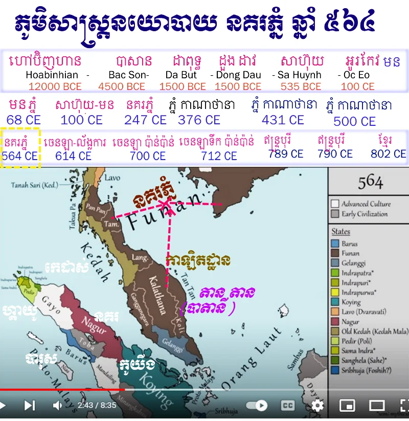
នគរវ្នំត្រូវបានគេគិតថាបង្កើតឡើងនៅក្នុងសតវត្សទី ១នៃគ.ស នៅតំបន់ដីសណ្ដទន្លេមេគង្គ ដែលបច្ចុប្បន្នគឺជាទឹកដី
ប្រទេសវៀតណាម ភស្តុតាងបុរាណវត្ថុបង្ហាញថាមានការតាំងទីលំនៅដ្ឋាននៃមនុស្សដ៏ច្រើន នៅតំបន់នេះប្រហែលជាត្រឡប់ទៅដល់សម័យសតវត្សទី៤ម.គ វិញ។ ថ្វីបើត្រូវបានចាត់ទុកដោយពួកបេសកជនចិនថាជាអាណាចក្រឯកភាពមួយក៏ដោយ ក៏នគរវ្នំប្រហែលជាបណ្ដុំនៃរដ្ឋបុរីដែលជួនកាលបានធ្វើចំបាំងជាមួយនិងរដ្ឋដទៃផ្សេងទៀត ហើយនៅពេលក្រោយមកទៀតក៏បានបង្រួបបង្រួមនយោបាយឡើងវិញ។ ដើមកំណើតពិតនៃពួកអ្នកនគរវ្នំគឺជាប្រជាជនដើម ដែលតាំងលំនៅនៅវៀតណាមខាងត្បូងសព្វថ្ងៃនេះ ដែលចាត់ទុកខ្លួនឯងថាជា ខ្មែរ ឬខ្មែរក្រោម។ ពាក្យខ្មែរ ក្រោម មានន័យថា ខាងក្រោម ឬ ប៉ែកខាងក្រោម សំដៅលើភាគក្រោមនៃទឹកដីខ្មែរដែលត្រូវបានធ្វើអាណានិគម ដោយវៀតណាមរួចទៅហើយក្រោយមកបានប្រែក្លាយ ជាផ្នែកមួយនៃវៀតណាមរហូតមកទល់សព្វថ្ងៃនេះ។ នៅមុនពេលសង្គ្រាមសកលលោកលើកទី១ គេនៅមានកង្វែងគំនិតគ្នាអំពីទីតាំងនគរវ្នំនៅឡើយ។ មានអ្នកប្រាជ្ញមួយចំនួនដូចជាលោកវីលផ្វដ (Wilford) លោកថាវ្នំស្ថិតនៅត្រង់ប្រទេស
ប្រទេសម៉ាឡេសុី។ លោកអា.រ៉ែមមុសាត (A.Remusat) លោកថាវ្នំជាអាណាខេត្តរបស់ចិន ស្ថិតនៅត្រង់តុងកឹង។ លោកខ្លាបផ្រថ (Klaproth) និង ផូសៀ (Pauthier) ថាវ្នំត្រូវនឹងដែនដីបាគូ និងប្រទេស
ប្រទេសភូមា។ លោកដឺឃ្វីនណេស (Dequines) ថាត្រូវនឹងកោះមួយនៅខាងលិចប្រទេសសៀម។ ឯលោកបាថ (Barth) ថាត្រូវនឹងឆ្នេរសមុទ្រ
តៈនាវឝ្រី ក្រៅពីនេះអ្នកសិក្សាឯទៀតយល់ថាវ្នំស្ថិតនៅត្រង់ប្រទេសខ្មែរ រឺ ប្រទេសសៀម។ ដើម្បីឲ្យអស់ចំងល់ចំពោះទីតាំងរបស់វ្នំ យើងនឹងលើកយកឯកសារចិនយកមកពិនិត្យឡើងវិញ។ ឯកសារចិនបានផ្ដល់ព័ត៌មានដូចតទៅ៖
- ភ្នំ ឬ វ្នំ មាន ចំងាយ ៣០០០ លី ខាងលិចប្រទេសលីនយី (ចាម្ប៉ា)
- វ្នំមានចំងាយ ៧០០០ លី ពី ចេណាន (Jenan) (តុងកឹង)
- វ្នំមានទំហំ ៣០០០ លី ក្រោយពង្រីកធំដល់ ៥០០០ រឺ ៦០០០ លី
- វ្នំស្ថិតនៅក្នុងឈូងសមុទ្រធំមួយ
- មានទន្លេធំមួយហូរពីខាងលិច (ឯកសារខ្លះពាយព្យ) ហើយចាក់ទៅសមុទ្រ។
បើសិនគិតថា ១ លី ប្រវែង ៥៧៦ មាត្រ ចំងាយពីលីនយីមកវ្នំមាន ១៧២៨ គ.ម គឺត្រូវនឹងប្រទេសខ្មែរសព្វថ្ងៃនេះ កម្ពុជាក្រោម និងប្រទេសថៃកណ្ដាល។ ឈូងសមុទ្រក្នុងឯកសារចិនគឺជាឈូងសមុទ្រថៃ ឯទន្លេធំដែលហូរចាក់ទៅ ក្នុងសមុទ្រគឺគ្មានអ្វីក្រៅពីទន្លេមេគង្គ រឺ បើនិយាយឲ្យចំទៅគឺទន្លេសាបនឹងឯង។ សរុបសេចក្ដីមកឃើញថាមជ្ឈមណ្ឌលវ្នំ ស្ថិតនៅត្រង់វាលទំនាបខាងក្រោមនៃទន្លេមេគង្គ។ ត្រង់នេះអ្នកសិក្សាហាក់ដូចជាយល់ស្របគ្នា ហើយតែចំណុចមួយទៀតដែលអ្នកសិក្សានៅមិនហ៊ានអារកាត់នៅឡើយ គឺរឿងរាជធានីដំបូងរបស់វ្នំ។ បើតាមសិលាចារឹកសម័យក្រោយៗមកទៀតបានឲ្យដឹងថាក្រុង វ្យាធបុរ (បុរីនៃស្ដេចទាក់ដំរី) ដែលអ្នកប្រវត្តិវិទូចាត់ទុកថាជារាជធានីមួយរបស់នគរវ្នំ។ ចិនហៅរាជធានីនេះថា តូមូ ដែលលោកសឺដេសថាត្រូវនឹងពាក្យខ្មែរបុរាណថាទ្មាក់ រឺ ទល្មាក់ (អ្នកទាក់ដំរី)។ លោកយល់ទៀតថា ក្រុងវ្យាធបុរនេះស្ថិតនៅម្ដុំបាភ្នំ និងបាណាមក្នុង
ខេត្តព្រៃវែងសព្វថ្ងៃ។ ព្រះភិក្ខុប៉ាង-ខាត់ក៏មានព្រះយោបល់ដូច្នេះដែរ។ ព្រះអង្គបានសរសេរថា រាជធានីវ្យាធបុរ តាំងនៅតំបន់ស្រុកបាភ្នំទំនងជានៅភ្នំខ្សាច់បច្ចុប្បនេះ ព្រោះគេបានរកឃើញបុរាណដ្ឋាន និងបុរាណទេវរូបជាច្រើននៅទីនោះ។ សិលាចារឹកមួយនៅវត្តចក្រឹតនៅជើងភ្នំ ពីស.វ.ទី១០ បាននិយាយពីការកសាងទេវរូបព្រះឥសូរហៅថា អទ្រិវ្យាធបុរេឝ្វរ តំកល់នៅទីនោះ។ គួរកត់សំគាល់ម្យ៉ាងទៀតថា នៅតំបន់បាភ្នំ
ឈើកាច់សព្វថ្ងៃនេះមានភូមិជាច្រើនដែលមានឈ្មោះទាក់ទងនឹងដំរី គឺ
ភូមិរោងដំរី ភូមិក្បាលដំរី និង
ភូមិព្រៃដំរី។ តើយើងអាចកត់សំគាល់ថាឈ្មោះទាំងនេះ ជាអនុស្សាវរីយ៍រំលឹកដល់ ទីតាំងរាជធានីអាណាចក្រវ្នំបានទេ? តាមពង្សាវតាររាជវង្សលាំង ក្រុងនេះស្ថិតនៅប្រហែល ២០០ លី ពីសមុទ្រ បើគិតទៅគឺត្រូវនឹងចំងាយពីបាភ្នំទៅ អូរកែវ ដែលជាកំពង់ផែមួយរបស់វ្នំ។ នៅពេលសង្គ្រាមលោកលើកទីពីរ លោកល្វីស-ម៉លឡឺរ៉េត (Louis Malleret) អ្នកប្រាជ្ញបារាំងបានធ្វើកំណាយផ្សេងៗក្នុងដែនដីសណ្ដទន្លេមេគង្គ ហើយបានរកឃើញរមណីយដ្ឋាន អូរកែវនេះដែល លោកចាត់ទុកថាជាកំពង់ផែធំរបស់វ្នំ ព្រោះនៅទីនោះគឺនៅខាងត្បូងភ្នំបាថេ
ខេត្តក្រមួនស គេបានជីករកឃើញខឿនសំណង់ផ្សេងៗព្រមទាំងវត្ថុផ្សេងទៀតជាច្រើន ខ្លះមកពីចក្រភពរ៉ូម ខ្លះទៀតមកពីប្រទេសឥណ្ឌា និងខ្លះទៀតជាវត្ថុធ្វើពីថ្មរំលីង។ ដោយហេតុនេះហើយបានជាមានមតិខ្លះថាអូរកែវជារាជធានីដំបូងរបស់វ្នំ។
ប៉ុន្តែអ្នកប្រាជ្ញខ្លះទៀតយល់ឃើញផ្សេង ដូចលោកហ្សង់-បូអ៊ីសេលី (Jean Boisselier) យល់ថារាជធានីវ្នំស្ថិតនៅត្រង់វាលទំនាបខាងក្រោមទន្លេមេណាមវិញ ដោយសំអាងលើការរកឃើញរូបសំណាកខ្លះដែលធ្វើពីដីឥដ្ឋ។ បើតាមលោកគិតថារបស់នេះធ្វើនៅក្នុងស្រុកមិនមែនជារបស់យកពីក្រៅឡើយ។ ប៉ុន្តែអ្នកប្រាជ្ញបារាំងរូបនេះយល់ដែរថា នៅចុងសម័យវ្នំរាជធានីត្រូវបានប្ដូរទៅតាំង នៅម្ដុំនៅជិតពាមទន្លេមេគង្គខាងត្បូងប្រទេសកម្ពុជា។
[១២] មានកំណត់ត្រាជាច្រើនជាភាសាចិន ដែលចុះកាលបរិច្ឆេទពីសតវត្សទី៣ផ្ដើមជាមួយ សានគ័រជី (三國志) (
តំរានគរបី) ដែលបានបញ្ចប់បង្ហើយនៅឆ្នាំ ២៨៩ នៃ គ.ស ដោយលោក
ឆឹនឝូវ (陳壽) (២៣៣-២៩៧) ក្នុងនោះមានអង្គទូតតែពីរប៉ុណ្ណោះទេដែលមកពីនគរវ្នំអំឡុងសតវត្សទី៣ត្រូវបានកត់ត្រាថា៖ អង្គទូតលើកទីមួយចូលទៅកាន់សំណាក់លោកហ្លីតាយ (呂待) ចៅហ្វាយខេត្តនៅភាគខាងត្បូងនៃនគរអ៊ូ 吳 ចិន ប្រ.រវាងឆ្នាំ ២២៥ និង ២៣០ គ.ស លើកទី២នៅឆ្នាំ ២៤៣។
[១៣] ក៏ប៉ុន្តែប្រភពក្រោយៗទៀតដូចជា លាំងឝ៊ូ (梁書) (
ក្រាំងលាំង) ដោយលោក
ហ្យ៉ោឆា (姚察) (៥៣៣-៦០៦) និង
ហ្យ៉ោហ្ស៊ឺហ្លៀន (姚思廉) (ម.៦៣៧) ដែលបានបញ្ចប់នៅឆ្នាំ ៦៣៦ បញ្ជាក់ថាគណៈទូតនៃពួកបេសកជនចិន លោក
ខាងថាយ 康泰 និង
ជូយិង (Zhū Yīng 朱應) ថាជាបេសកជនទៅកាន់នគរវ្នំនៅសតវត្សទី៣។
ហ៊ុនធៀន (ហ៊ុនហ្ធៀន)
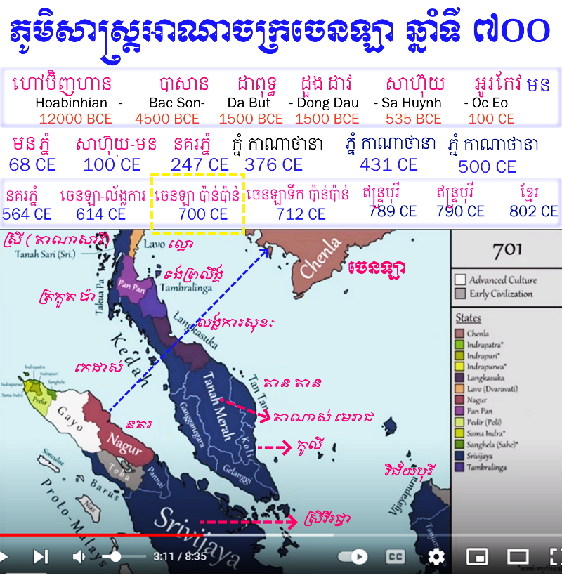
ពង្សាវតារនៃរាជវង្សលាំងកត់ត្រាអំពីរឿងរ៉ាវនៃជនបរទេសម្នាក់ដែលមានឈ្មោះថា ហ៊ុនហ្ធៀន 混塡 ៖ ព្រះអង្គបានមកពីប្រទេសខាងត្បូងជាំវ 徼 (ជ្វា) (ឧបទ្វីបម៉ាឡេ រឺ ប្រជុំកោះឥណ្ឌូនេស៊ី?) បន្ទាប់ពីបានសុបិនថាទេពារក្សព្រះអង្គបានប្រគល់ធ្នូទិព្វទៅឱ្យទ្រង់ បានបង្គាប់ឱ្យព្រះអង្គចេញដំណើរតាមសំពៅជំនួញដ៏ធំមួយ។ ព្រះអង្គបានចេញដំណើរនៅពេលព្រឹកទៅកាន់ប្រាសាទមួយ ជាកន្លែងដែលព្រះអង្គរកឃើញធ្នូមួយនៅឯគល់នៃដើមឈើរបស់ទេពារក្សនោះ។ ព្រះអង្គក្រោយមកបានឡើងសំពៅមួយ ហើយទេពារក្សបានបណ្ដាលឲ្យចិត្តព្រះអង្គទៅដល់ទឹកដីវ្នំ។ ម្ចាស់ក្សត្រីនៃប្រទេសនេះ គឺព្រះនាង លៀវយ៉េក រឺ លីវយី 柳葉 (ស្លឹកសូល) ចង់ឆ្មក់យកសំពៅនិងពន្លិច ដូច្នេះហើយកុរុងហ៊ុនធៀនបានបាញ់ព្រួញចេញពីធ្នូទិព្វទំលុះសំពៅរបស់លីវយី។ ដោយភិតភ័យ ព្រះនាងបានប្រគល់ខ្លួនចុះចាញ់ ហើយហ៊ុនធៀនបានយកព្រះនាងធ្វើជាព្រះមហេសីរបស់ព្រះអង្គ។ ប៉ុន្តែដោយមិនសប្បាយចិត្តដែលឃើញព្រះនាងស្រាតននល ព្រះអង្គក៏បានដណ្ដប់វត្ថុអ្វីមួយដើម្បីធ្វើជាសំលៀកបំពាក់ ដែលព្រះអង្គបានបំពាក់កន្លងព្រះសិរសាព្រះនាង។ ក្រោយមកទៀតទ្រង់ក៏បានគ្រប់គ្រងប្រទេសនេះ នឹងបន្តអំណាចទៅឱ្យបុត្រារបស់ព្រះអង្គ ដែលជាស្ថាបនិកនៃទីក្រុងទាំងប្រាំពីរ។ ស្ទើរតែជារឿងដូចគ្នាហើយបានលេចឡើងក្នុង ជិនឝ៊ូ 晉書 រឺ ពង្សាវតាររាជវង្សជិន បានចងក្រងដោយលោក
ហ្ផ្វាងហ្ស្ឈែនលិង 房玄齡 (៥៧៨-៦៤៨) នៅឆ្នាំ ៦៤៨គ.ស. មានតែឈ្មោះទេត្រូវបានផ្លាស់ប្ដូរទៅជា ហ៊ុនហួយ 混湏 និង យ៉េកលៀវ 葉柳។
៤) ជាចុងក្រោយគឺ សៀវភៅ ប្រវត្តិសាស្ត្រប្រទេសកម្ពុជា ដោយលោក វង់ សុធារ៉ា និង លោក ណុប សុខា ដែលជាសាស្រ្តាចារ្យដេប៉ាតឺម៉ង់ប្រវត្តិវិទ្យា នៅសាកលវិទ្យាល័យភូមិន្ទភ្នំពេញ២ ដែលដកស្រង់យកអំណះអំណាងរបស់លោក ម៉ាយឃើល វីគឃីរី (Michael Vickery) ដែលមើលទៅ ជាអំណះអំណាងថ្មីជាងគេបំផុត និងសមស្របជាងគេបំផុតដែរ ។ អំណះអំណាងនោះគឺ៖
ក. ពាក្យ វ្យាធៈ ជាភាសាសំស្រ្តឹតត្រូវនឹងពាក្យបារាំងថា frapper ដែលប្រែថា វាយ ទះ តប់ ។ ខ. នៅឆ្នាំ១៩៩៦ កំណាយបុរាណវិទ្យាដោយ បុរាណវិទូជប៉ុន និងអាមេរិច រួមសហការដោយបុរាណវិទូខ្មែរនៅសកលវិទ្យាល័យភូមិន្ទវិចិត្រសិល្បៈ ។ កំណាយ និងការពិនិត្យរូបភាពពីលើអាកាស បាននាំឲ្យគេអះអាងថា នៅបាភ្នំគ្មានភស្តុតាងជាអតីតទីក្រុងបែបណាមួយទេ ។ គ. កំណាយនៅ វត្តគំនូរ ការសិក្សាលើសំណស់បុរាណវត្ថុ និងរូបថតពីលើអាកាសនៅអង្គរបុរី បានបង្ហាញភស្តុតាងពីទីក្រុងបុរាណដែលអាចមានមនុស្សរស់នៅតាំងពីមុន គ.ស រហូតដល់សតវត្សទី ៧ នៃគ.ស ។ ឃ. សិលាចារឹក បន្ទាយប្រាវ K. 222 នាសតវត្សទី ១១ មានជួរមួយសរសេរថា លោញវ្រៃក្របាសវ្យាធបុរ ដែលមានន័យថា លោញនៃស្រុកព្រៃក្របាសក្នុងដែនដីវ្យាធបុរៈ ។ ព្រៃក្របាស នោះត្រូវនឹងស្រុកព្រៃកប្បាស នៅខេត្រតាកែវ សព្វថ្ងៃ ។
ជាចុងក្រោយ ពួកគាត់បានសរសេរថា […] វាអាចមានន័យថា រាជធានី វ្យាធបុរៈ ពិតជាត្រូវនឹងទីតាំង អង្គរបុរី […] ។
ព្រះបាត កៅណ្ឌិន្យ
ពួកអ្នកប្រាជ្ញខ្លះបានព្យាយាមបញ្ចូលទេវកថានេះ ជាមួយរឿងព្រាហ្មណ៍ម្នាក់ ដែលមាននាមថា កៅណ្ឌិន្យដែលបានរៀបអភិសេកជាមួយបុត្រីនាគ (ពស់) ដែលមានព្រះនាមថា
សោមា ដែលដំបូងយោងទៅតាមសិលាចារឹកចាមមួយ ដែលមានចុះកាលបរិច្ឆេទ ៦៥៨ គ.ស (សូមមើលខាងក្រោម)។ វិខ្ខឺរី (Vickery)
[១៤] បានច្រានចោលដោយកែតំរូវទៅលើភាពដូចគ្នានេះ ដោយបង្ហាញថា ហ៊ុនធៀន មានត្រឹមតែពីរព្យាង្គប៉ុណ្ណោះ (ការបញ្ចេញសំឡេងបានសង់ឡើងវិញគឺអនុលោមតាម ភូឡេប៊្លែងខ៍
[១៥] γwәn dεn): "...វាគួរឲ្យដឹងថា គ្មានឯកសារណាដែលបានផ្ដល់នូវព្យាង្គទីបី [a] ទេ ដោយហេតុថាតាមការសិក្សាខាងចិនវិទ្យាបានសង្កត់ធ្ងន់ថា ភាសាចិនមានសមត្ថភាពដ៏អស្ចារ្យ ក្នុងការកត់ឈ្មោះតាមភាសាមួយទៅភាសាមួយទៀតជាប្រព័ន្ធពីទីដទៃទៀតនៃអាស៊ី ជាពិសេសឈ្មោះនោះជាភាសាឥណ្ឌា។" បន្ថែមលើសពីនេះ គួរឲ្យកត់សំគាល់ដែរ ព្រោះរឿងនេះក៏មិនបញ្ជាក់ថាហ៊ុនធៀនជាព្រាហ្មណ៍ រឺ លីវយីជាបុត្រីនាគដែរ។
កៅណ្ឌិន្យក្នុងប្រភពចិន
បន្ថែមទៀតនោះដែរ ការប្រែជាភាសាចិននៃកៅណ្ឌិន្យ រឺ កោណ្ឌញ្ញ។ល។ គឺត្រូវនឹង ឈ្ហាំវឆ្ហឹនយូ 僑陳如។
[១៦] មនុស្សម្នាក់ដែលត្រូវបានយកមកវែកញែកដែរនៅក្នុង លាំងឝ៊ូ តាមរយៈប្រភពនេះកៅណ្ឌិន្យ គឺជាអ្នកស្នងរាជ្យបន្តនៃកុរុង
ចន្ទន រឺ ធៀនជូចានថាន 天竺旃檀 (“ចន្ទន មកពីឥណ្ឌា”) ជាព្រះរាជាមួយអង្គនៃនគរវ្នំ ដែលបានបញ្ជូនដំរីផ្សាំងមួយចំនួនក្នុងឆ្នាំ ៣៥៧ គ.ស ជាសួយសារទៅព្រះចៅអធិរាជចិន
ស៊ឺម៉ាតាន 司馬聃 (រ.៣៤៤-៣៦១ ឈ្មោះជាអនុស្សាវរីយ៍៖ មូទី 穆帝)៖ ព្រះអង្គកៅណ្ឌិន្យ រឺ ឈ្ហាំវឆ្ហឹនយូ[Qiáochénrú]ដើមឡើយជាព្រាហ្មណ៍ម្នាក់មកពីឥណ្ឌា។ មានសំឡេងមួយប្រាប់ទ្រង់ថា៖ʻលោកត្រូវតែទៅសោយរាជ្យនៅវ្នំʼ ហើយព្រះអង្គបានសប្បាយក្នុងព្រះហឫទ័យណាស់។ ទៅទិសខាងត្បូង ព្រះអង្គមកដល់វ្នំដោយឆ្លងកាត់នគរ
ផានផាន 盤盤 (ប្រទេសមួយនៅជ្រោយម៉ាឡេយូ)។ ប្រជារាស្ត្រវ្នំបានបង្ហាញទៅកាន់ទ្រង់ថា នគរទាំងមូលបានរះឡើងជាមួយភាពសប្បាយរីករាយ បន្ទាប់ពីទ្រង់បានមកដល់ ហើយក៏បានជ្រើសរើសទ្រង់ធ្វើជា
ស្ដេច។ ព្រះអង្គបានផ្លាស់ប្ដូរច្បាប់ទាំងអស់ ដើម្បីអនុលោមតាមប្រព័ន្ធនៃ
ច្បាប់ឥណ្ឌា។
ការគាប់ជួននៃឈ្មោះ "កៅណ្ឌិន្យ" ក្នុងប្រវត្តិនគរវ្នំ
” នាម កៅណ្ឌិន្យ ល្បីល្បាញដោយសារសិលាចារឹកទមិឡមួយចំនួន នៅភាគខាងត្បូងប្រទេសឥណ្ឌានៅសហវត្សទី១នៃគ.ស. និងទំនងជានគរវ្នំត្រូវបានគ្រប់គ្រងឡើង នៅសតវត្សទី៦ដោយគោត្រនាមដដែលនេះ។ តាមរយៈ ណាន់ឈ៊្ហីកស្ឈូក 南齊書 រឺ កំណត់ត្រាប្រវត្តិសាស្ត្រនៃរាជវង្សស្ឈីខាងត្បូង”) ដោយលោក
ស្ឈាំវហ្ស៊ឺស្ឆៀន 簫子顯 (៤៨៥-៥៣៧) ស្ដេចនគរវ្នំ ឈ្ហាំវឆ្ហឹនយូទូយ្ហេកប៉ាម័រ 僑陳如闍耶跋摩 (កៅណ្ឌិន្យជយវម៌្ម) បានបញ្ជូនព្រះសង្ឃមួយអង្គនៅឆ្នាំ ៤៨៤ ព្រះនាមណាឈ៊្ហែកស្ហៀន 那伽仙 (នាគសេន) ដើម្បីនាំជំនូនទៅកាន់ព្រះចៅអធិរាជចិននិងទូលសុំឲ្យព្រះចៅអធិរាជ នៅខណៈពេលនោះឱ្យជួយនៅក្នុងការធ្វើសញ្ជ័យយក លិនយិ 臨沂 (ភាគខាងជើងចាម្ប៉ា) …ព្រះចៅអធិរាជចិនបានអរព្រះគុណកុរុងជយវម៌្មចំពោះជំនូនរបស់ទ្រង់ ក៏ប៉ុន្តែទ្រង់មិនបានបញ្ជូនកងទ័ពទៅតទល់នឹងលិនយិទេ”។
[១៧]
កៅណ្ឌិន្យនៅក្នុងសិលាចារឹកប្រាសាទប្រាំល្វែង (ថាបមឿយ) តំបន់រដ្ឋ មេ ស នៅ ចម្ប៉ា ( មេសាង នៅកម្ពុជា)
សិលាចារឹកមួយក្នុងចំណោមសិលាចារឹកដំបូងគេបង្អស់ របស់កម្ពុជាមកពីប្រាសាទប្រាំល្វែងនៅ “វាលដើមត្រែង” (ថាបមឿយ) នៅកម្ពុជាក្រោម (K.5) បញ្ជាក់ពីព្រះអង្គម្ចាស់មួយអង្គព្រះនាម
គុណវម៌្ម បុត្រាវ័យក្មេងជាងគេ (nṛpasunu—bālo pi) នៃកុរុងជយវម៌្ម គឺជាអ្នក “ដែលជាប់សោមវង្សនៃវង្សកៅណ្ឌិន្យ (… កៅណ្ឌិន្យវង្សសសិនា …) និងជាអធិបតីនៃ “អាណាចក្រមួយដែលបានទាញចេញពីភក់” ។
[១៨] ញាតិខាងកៅណ្ឌិន្យនេះល្បីល្បាញណាស់ បុព្វបុរសស្ថាបនិករបស់ព្រះអង្គនៅពេលក្រោយមកទៀត (ពីសតវត្សទី៧ក្រោយមកខាងមុខទៀត) ត្រូវបានគេរៀបចំឱ្យក្លាយជាឫសីមួយអង្គឱ្យដូចក្នុងវីរកថារបស់ឥណ្ឌា
មហាភារតៈ ទោះបីយ៉ាងនេះ តួអង្គនេះនៅតែគេមិនស្គាល់ព្រះនាមពិតជាដដែល។
កៅណ្ឌិន្យនៅក្នុងសិលាចារឹកភទ្រេស្វរៈ (មីសឺន) តំបន់រដ្ឋ មេ ស នៅ ចម្ប៉ា ( មេសាង នៅកម្ពុជា)
ជាលើកទីមួយរឿងនេះបានលេចឡើងនៅក្នុងសិលាចារឹកមីសឺន C. ៩៦ ដែលបានចុះកាលបរិច្ឆេទថ្ងៃ អាទិត្យ ១៨ កុម្ភៈ ឆ្នាំ ៦៥៨ នៃ គ.ស (វគ្គទី១៦-១៨)
[១៩]: "នៅឯ[ទីក្រុង
ភវបុរ ]
កៅណ្ឌិន្យ ជាអ្នកដំបូងក្នុងចំណោមពួកព្រាហ្មណ៍បានពួយ
លំពែង ដែលលោកបានទទួលពីបុត្ររបស់
ទ្រោណ អឝ្វតថាមន ជាព្រាហ្មណ៍ប្រពៃបំផុតក្នុងចំណោមពួក
ព្រាហ្មណ៍។ មានបុត្រីនៃ
ស្ដេចភុជង្គនាគមួយអង្គ ព្រះនាម
សោមា ដែលបានសាង
គ្រួសារនៅលើលោកិយ។ ដោយទទួលបានសេចក្ដីស្នេហានឹងជាតិផ្សេងគ្នា
ព្រះនាងក៏បានរស់នៅក្នុងសំណាក់នៃពួកមនុស្ស។ ព្រះនាងបានក្លាយជាព្រះមហេសីរបស់ព្រាហ្មណ៍ដ៏ខ្ពង់ខ្ពស់ កៅណ្ឌិន្យ ដើម្បីជាប្រយោជន៍ (ការបំពេញ)...ក្នុងកិច្ចការខ្លះ ។
[២០] ក៏ប៉ុន្តែ រឿងនេះមានក្នុងសម័យក្រោយនគរវ្នំទេ។
រាជវង្សដំបូង
បើតាម
ពង្សាវតាររាជវង្សលាំង ហ៊ុនធៀនមានបុត្រមួយអង្គដែលបានទៅត្រួតត្រាលើទឹកដីមួយផ្នែកដែលមានក្រុងប្រាំពីរ។ ក្នុងចំណោមអ្នកសោយរាជ្យតមកមានស្ដេចឈ្មោះ
ហ៊ុនផានហួង ។ កាលណោះក្រុងទាំងប្រាំពីរនោះមានចិត្តកំរើបចង់បានឯករាជ្យពីនគរវ្នំ ស្ដេចអង្គនេះក៏បានប្រើឧបាយកលផ្សេងៗដើម្បីឲ្យ
ក្រុងទាំងនោះបែកបាក់គ្នា រួចទ្រង់ក៏ឆ្លៀតឱកាសលើកទ័ពយកទៅវាយយកបានទាំងអស់។ បន្ទាប់មកបានចាត់ឲ្យកូនចៅរបស់ព្រះអង្គគ្រប់គ្រងត្រួតត្រា ក្រុងទាំងនោះម្នាក់មួយៗ។ ស្ដេចហ៊ុនផានហួង បានសោយទិវង្គតនៅពេលទ្រង់មានជន្មា ៩០ វស្សា។ បុត្រទីពីរព្រះនាម
ផានផាន ត្រូវលើកឲ្យឡើងសោយរាជ្យ ដោយទ្រង់បានប្រគល់កិច្ចការរដ្ឋទាំងឡាយឲ្យមេទ័ពម្នាក់ឈ្មោះ ផ្វានឝ៊ឺម៉ាន (ឝ្រីមារញ) មើលខុសត្រូវ។ ស្ដេចផានផានបានសោយរាជ្យបានតែ ៣ ឆ្នាំ ក៏បានសោយទិវង្គតទៅ។ ប្រជារាស្ត្រក៏បានព្រមព្រៀងគ្នាឲ្យលើកឝ្រីមារញឲ្យឡើងសោយរាជ្យជំនួស។ ស្ដេចអង្គនេះមានសេចក្ដីក្លាហាន ហើយមានឫទ្ធានុភាពណាស់ ព្រះអង្គបានលើកទ័ពទៅវាយយកប្រទេសជិតខាងដាក់ជាចំណុះអស់ជាច្រើន។ ព្រះអង្គទ្រង់ប្រកាសខ្លួនថាជា មហារាជនៃភ្វូណាន ។ បន្ទាប់មកទ្រង់បញ្ជាឲ្យធ្វើសំពៅធំៗជិះកាត់សមុទ្រទៅវាយនគរជាង១០ ដែលក្នុងចំណោមនោះមាននគរ គីវទួគុន (k'iu-tou-k'ouen) កៀវឆេ (Kieou-tche) ទៀនស៊ុន (Tien-Souen)។ ព្រះអង្គបានពង្រីកទឹកដីធំរហូតដល់ ៥ រឺ ៦ ពាន់
លី។
ឯកសារចិនបានបញ្ជាក់ថាស្ដេច ឝ្រីមារញ បានសោយទិវង្គតនៅពេលលើកទ័ពទៅវាយរដ្ឋ គីនលីន (
កំពែងមាស) ដែលលោកសឺដេស ថាត្រូវនឹង សុវណ្ណភូមិ (ដីមាសក្នុងអត្ថបទបាលី) រឺ
សុវណ៌កុដ្យ (កំពែងមាសក្នុងអត្ថបទសំស្ក្រឹត.នៅប្រទេសភូមាខាងត្បូង រឺ លើ
ជ្រោយម៉ាឡេយូ)។ នៅពេលដែលទ្រង់ប្រឈួន
ឝ្រីមារវម៌្ម ទ្រង់បានបញ្ជូនរាជបុត្រឈ្មោះ
ជិនឝឹង ឲ្យទៅសោយរាជ្យជាជំនួសព្រះអង្គ។ ពេលនោះក្មួយព្រះអង្គឈ្មោះ ធរណីន្ទ្រ (ផ្វាន់ឆាន រឺ ធរណីន្ទ្រវម៌្ម) (កូននៃបងស្រីរបស់ព្រះអង្គ) ដែលជា
មេត្រួតទ័ព ២០០០ នាក់ ក៏បានជ្រែករាជ្យធ្វើគត់រាជទាយាទជិនឝឹង។ ពេលដែលឝ្រីមារវម៌្មបានសោយទិវង្គតទៅ ព្រះអង្គនៅមានបុត្រមួយអង្គទៀត ប៉ុន្តែនៅបៅដោះនៅឡើយ។ បុត្រអង្គនោះឈ្មោះ ឆាង (ផ្វានឆាង) បានរស់នៅក្នុងចំណោមប្រជានុរាស្ត្រ។ លុះធំបានព្រះជន្ម ២០ វស្សាបានប្រមូលស្ម័គ្របក្សពួកទៅធ្វើគត់ធរណីន្ទ្រវិញ។ ក៏ប៉ុន្តែមេទ័ពម្នាក់របស់ធរណីន្ទ្របានធ្វើគត់ព្រះអង្គ ហើយបានឡើ់ងសោយរាជ្យជាជំនួសវិញ។ ព្រះអង្គទ្រង់បានបញ្ជាឲ្យកសាងកន្លែងកំសាន្តផ្សេងៗ។ ព្រឹកនិងថ្ងៃត្រង់ ទ្រង់ប្រទានសវនការ ៣ រឺ ៤ ដង។ ជនបរទេស និងប្រជារាស្ត្របានថ្វាយ
ចេក អំពៅ អណ្ដើក និង
សត្វបក្សី...។ ព្រឹត្តិការណ៍នេះបានកើតឡើងតាំងពីឝ្រីមារសោយទិវង្គត និងរហូតដល់
អស្សាជយ ឡើងសោយរាជ្យគឺនៅរវាងឆ្នាំ ២២៥ និង ២៥០។ នៅចន្លោះកាលកំណត់ទាំងពីរនេះ ក្នុងរជ្ជកាលរបស់
ធរណីន្ទ្រវម៌្ម ដែលអាណាចក្រវ្នំមានទំនាក់ទំនងជាមួយនឹងរាជវង្ស
មុរុណ្ឌនៅឥណ្ឌានិងបញ្ជូនរាជទូតទី១ទៅកាន់ចិន។ បើតាមពង្សាវតារនគរបីចិន ធរណីន្ទ្រវម៌្មនេះហើយបានបញ្ជូនរាជទូតទី១ទៅប្រទេសចិននៅឆ្នាំ ២៤៣ នៃ គ.ស. ដើម្បីនាំភ្លេងនិងផលិតផលទៅថ្វាយស្ដេចចិន។ គេអាចចោទសួរថាតើ
ធរណីន្ទ្រវម៌្មទី១នេះហើយ ដែលជាអ្នកនិពន្ធសិលាចារឹកវ៉ូកាញ់ដែលអះអាងថាព្រះអង្គជាញាតិនៃកុរុង
ឝ្រីមារ?
អស្សាជយបានឡើងសោយរាជ្យបន្តពី
ធរណីន្ទ្រវម៌្ម ក្រោយពីបានធ្វើគត់បុត្ររបស់កុរុងឝ្រីមារវម៌្មរួច បានទទួលនៅប្រមាណឆ្នាំ ២៤៥-២៥០ នូវគណៈទូតរបស់លោក
ខាងថាយ និងលោក
ឈូយីង ដែលបានមកជួបគ្នាជាមួយទូតឥណ្ឌានៅក្នុងរាជវាំង។ បន្ទាប់ពីនោះស្ដេចអស្សាជយ ក៏បានបញ្ជូនទៅប្រទេសចិនវិញនៅរវាងឆ្នាំ ២៦៨ ដល់ ២៨៧ ហើយដែលបានកត់ត្រានៅក្នុង
ពង្សាវតាររាជវង្សជិនចិន។ តាមការប៉ាន់ស្មានការបញ្ជូនទូតបីលើកចុងក្រោយក្នុងឆ្នាំ ២៨៥ ដល់ ២៨៧ ទំនងជាហុចផលដល់សន្ទុះនៃជំនួញផ្លូវសមុទ្រក្រោយ ពីប្រទេសចិនបានឯកភាពឡើងវិញ ដោយរាជវង្សជិនព្រោះព្រឹត្តិការណ៍នេះបានបំពេញ ដល់សេចក្ដីត្រូវការវត្ថុប្រណិតរបស់ពួកស្ដេចចិនជាច្រើន។
នគរវ្នំបានធ្លាក់ចុះនៅសតវត្សទី៦ និងត្រូវបានលេបត្របាក់ដោយ
កម្វុជ ដែលជាអ្នកដែលមិនអាចប្រកែកបានថាគឺជាពួក
ខ្មែរ។ សិលាចារឹកជាភាសាខ្មែរបុរាណលើកដំបូងបានចុះកាលបរិច្ឆេទ ដោយខ្លីបន្ទាប់ពីការដួលរលំនៃនគរវ្នំ ហើយការចុះកាលបរិច្ឆេទទាំងនោះដោយកាលបរិច្ឆេទ ក្រោយមកទៀតត្រូវបានប្រមូលនៅកម្ពុជាភាគខាងត្បូងនិយាយថា ខ្មែរបានតាំងលំនៅរួចទៅហើយនៅឯទឹកដីកម្ពុជាភាគខាងក្រោម។
[២៤] វីខខឺរីបានឲ្យយោបល់ថា “តាមភស្តុតាងបច្ចុប្បន្នវាមិនអាចទៅរួចទេ ដោយបញ្ជាក់អះអាងថា នគរវ្នំជាតំបន់ និងពួកអ្នកគ្រប់គ្រងនៅនគរវ្នំ មិនមែនជាជនជាតិខ្មែរ” ។
[២៥] វ្នំត្រូវបានចាត់ទុកថាជានគរខ្មែរទីមួយ និងជានគរមុននៃ
កម្វុជទេឝ។
អាណាចក្រភ្នំ ភ្វូណាន ឬ ហ្វូណាន